The Create North Arrow tool converts a selected symbol into a directional true north arrow.
In this process, the selected symbol is rotated toward true north at its location. This property is maintained through subsequent moves of the map, projection or rotation.
The true north is the direction to the geographic North Pole — this direction may vary on a map depending on the selected MAP View coordinate system. To visualize this, think of the lines of latitude in a graticule (see more about Graticules) — these lines can be straight or curved.
 True north usually differs from the magnetic north (the direction of the magnetic north pole, which varies in time and space) and grid north (the direction northwards along the measured grid of a projected map).
Requirements
Any Adobe Illustrator symbol may be used to create a north arrow. The only requirement is that the symbol is placed on a Legend layer (within a MAP View) and must be selected.
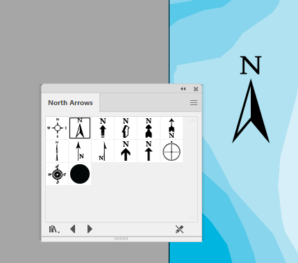
 Sample north arrow symbol designs are included with MAPublisher. In the Symbols panel options menu, choose Open Symbol Library > MAP Symbols > Other Symbols > North Arrows.
Creating a North Arrow
Select the symbol to be converted to a north arrow and click the North Arrow button on the MAPublisher toolbar. Alternatively, from the main menu Object > MAPublisher > Create North Arrow.
Upon creation, the selected symbol is aligned to true north, based on the coordinate system of the MAP View and its position on the map. If the north arrow symbol is repositioned on the map, it will be re-oriented to true north at the new location.
 If the selected art is not already a symbol, it needs to be converted to an Adobe Illustrator symbol. Simply add it to the Adobe Illustrator Symbols panel.
Configuring North Arrow
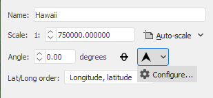
In the MAP View Editor, click the Orient Data Up drop-down arrow and select Configure to access available settings.
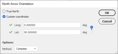
The North Arrow Orientation settings allow you to provide an orientation to either True North or a custom coordinate, such as Magnetic North (since this may change over time). The Method drop-down provides two more orientation options: Great Circle and Compass. Use the Great Circle method when you need to orient using the shortest distance based on a globe. Use the Compass (rhumb line) method when you need to orient using a Euclidean space (e.g. Mercator projection).
Comments
0 comments
Please sign in to leave a comment.