MAPublisher has the ability to export the entire working artboard or document as tiled images based on several map provider formats for use in web-based GIS.
Requirements
The MAP View must be non-rotated and have a WGS84/Pseudo-Mercator coordinate system before exporting to web tiles. An Internet connection is required to use the online map providers after export.
Features must be within the acceptable export extents. The minimum/maximum latitude is -85/+85 degrees and the minimum/maximum longitude is -180/+180 degrees.
Using Export Document To Web Tiles
In the Export Document To Web Tiles dialogue box, choose the source either as a specific artboard or all art in the document. If multiple artboards are present, click the drop-down list and choose the appropriate artboard. The Referencing drop-down list specifies which MAP View will be used and must be WGS84/Pseudo-Mercator compatible. In the Destination section, choose a map provider, specify a dataset name, and output folder.

Several map providers are available in the drop-down list: Google Maps, Bing Maps, OpenStreetMap, Tile Map Service, MapBox and GeoPackage. Only the map providers Google Maps, Bing Maps and OpenStreetMap create a compatible HTML file that combines the web tiles and uses their respective basemap style. The Tile Map Service creates an XML file and associated web tiles. MapBox creates a file with a mbtiles extension compatible with the MapBox online system. GeoPackage creates a GPKG file, an open format that is primarily used on mobile devices.
Zoom Level tab
The Maximum zoom drop-down determines the web tile level and map scale that will be created. The zoom level value ranges from 1 to 23 (depending on map provider), where an associated map scale is shown for each level of zoom. Specify the number of Zoom levels up to a maximum of the level chosen in the Maximum zoom drop-down. Higher level values will create more web tiles (indicated by the Total tiles value).
Options tab
Click the Options tab to view available settings.

Anti-aliasing improves image quality; choose between Art Optimized and Type Optimized. Web tiles can be created in PNG or JPEG image format. Depending on the Image format chosen, each format has several specific options available. The Compression option is only available for the PNG format, with a compression range of 1 to 9 (1 being lowest, and 9 being highest). The Quality option is only available for the JPEG format, with a quality range of 10 to 100 (10 being lowest and 100 being highest). The Include transparency option is only applicable to the PNG format. Depending on the compression or quality value, output web tile file sizes will vary. Use the Opacity slider to set the transparency of web tiles: 0% is completely transparent and 100% is completely opaque.
Google Maps tab
Click the Google Maps tab to view available settings. These options only apply to Google Maps web tiles.
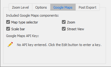
The available Google Map controls are added to the HTML file to aid in map navigation. A Google Maps API key (available from https://developers.google.com/maps/documentation/javascript/get-api-key) is required to use the Google Maps provider.
- Map Type Selector: An option to choose standard Map view or a Satellite view
- Scale Bar: A scale bar at the lower-left of the map
- Zoom: A zoom slider widget to zoom in and out of the map
- Overview Map: An overview map available at the lower-right of the map(collapsed by default)
- Pan: A pan widget to move the map
- Street View: An option to include the Google Street View feature
Bing Maps tab
Click the Bing Maps tab to view the available settings. A Bing Maps API key (available from https://www.bingmapsportal.com) is required to use the Bing Maps provider.

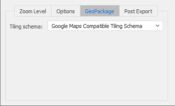
GeoPackage tab
Click the GeoPackage tab to view the available setting. Choose a compatible Tiling Schema for the GeoPackage as either Google Maps compatible or as Pseudo TMS Global Mercator.
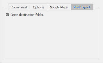
Post Export tab
Click the Post Export tab to view the available setting. When enabled, the destination folder containing the web tiles will be opened after export.
Advanced
The Advanced dialogue box has two options. Use the Export reference file option to output an associated georeference file with each tile in World, Blue Marble Reference, or ERS format. This option is disabled by default and does not output any reference files. Use the Export Coordinate System option to output coordinate system information in a WKT or PRJ file. This option is disabled by default and does not output any coordinate system files.
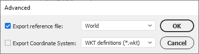
 World and ERS formats do not support coordinate systems. Choose Blue Marble Reference if there is a need to include coordinate system information in a reference file or use the other option to include a WKT or PRJ file.
Comments
0 comments
Please sign in to leave a comment.