Join Points allows a group of point symbols to be joined to form a line, based upon attribute values used as sorting criteria. For example, it is common to form a line based on points collected by a GPS device. When Join Points is completed, a new map layer is created that contains the line art. The generated line layer contains the same common attribute column that was used to group the points together.
Requirements
Join Points can only function on Point layers and can be used on both currently selected point symbols or all the point symbols on a specified layer. There must be at least two attribute columns on the specified point layer in order to use Join Points.
Using Join Points
To open the dialog box, click the Join > Join Points button on the MAPublisher toolbar or from the menu Object > MAPublisher > Join Points.

Source Layer
From the Source Layer drop-down list, select the Point layer containing the points to be joined. A join can be based on either all points on the source layer or Only join selected points.
Destination
Specify a name for the Destination Layer that this operation will generate. By default, the program will generate a Line layer. To generate an Area layer (by linking the line end to the start) check the Close paths option.
Group By
In the Group By Column drop-down list, select the attribute column containing the common attributes used to join the point together. For example, to join points based on a unique ID, select the column containing the common ID names. This will result in point symbols containing the same name being joined together.
A logical order by which the points are being joined must be specified because each point will be represented by a node in a line string. To properly join points, a sort order must be chosen based on an attribute column. These should be attribute columns that contain rising alphabetical or numerical values. For example, GPS data may contain an attribute that specifies the order in which the points were collected (first node, second node, etc).
Sort By
In the Sort By Available Columns list, select the primary sorting column. This should be the attribute column that contains the best fit for rising alphabetical or numerical values. For example if points have rising values from 1–10, the point with a value equal to 1 will be at the start of the generated line, and the point with a value equal to 10 will be at the end of the line. Select a column and then click the Add button to place the column into the Sort Order list. If all the values contained in the first Sort By column are unique, it is not required to set a secondary column.
If the first Sort By column contained any similar values, a secondary column must be specified. Again, click a column in the Sort By Available Columns list, and then click the Add button to place the column in the Sort Order list. Similarly third, fourth and fifth Sort By columns can be specified in the same manner if previous columns contain similar values. Note that the Sort By columns are a hierarchy with the topmost specified column being used for the primary sort, then the second, then third, etc.
To move columns up or down the hierarchy after they have been specified, simply select the appropriate column in the Sort Order list and click either the Up or Down button. To remove any Sort By columns from the hierarchy, select the column in the Sort Order list and click the Remove button.
 Note that a maximum of five columns can be used to sort points into a logical order. If the columns specified to sort by do not distinguish an ordering between certain points, the order of these points in the attribute table will be used to determine the order of the nodes in the generated line string.
Attributes
Click the Attributes tab to manage which attributes and operations are used.
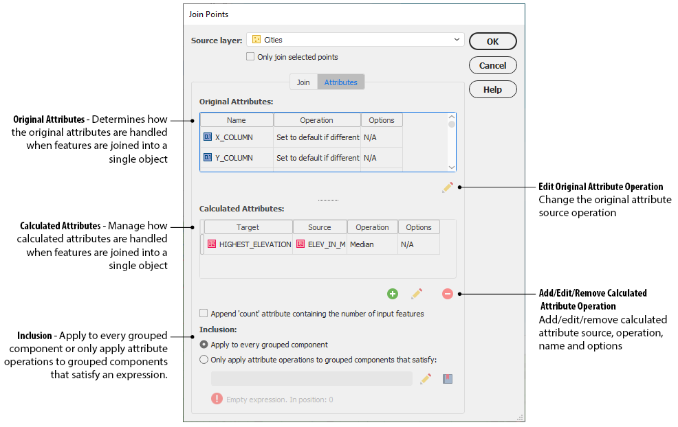
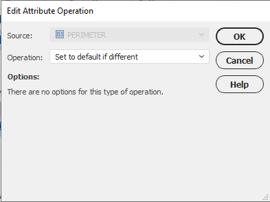
The Original Attributes are listed with their intended operation and associated options. Click the Edit Original Attribute Operation button to change the original attribute operation.
When points are joined, attributes are combined based on an operation. Often, these combinations are straightforward. However, depending on attribute and operation, some results may require additional thought. For example, after joining points created based on time, a field containing unique names will no longer be valid, as each continent does not have one capital. Thus, operations can be set to determine how each attribute field is handled. By default all attribute operations are Set to default if different, meaning that the attribute is cleared if there are more than two unique values present after the join.
Only certain operations are available for a specific attribute type. The following details the operation, which attribute types are affected, and its description.
|
Operation |
Affects Attribute Type |
Description |
|
Set to default |
All |
The original attribute is retained after the join. |
|
Set to default if different |
All |
The attribute is cleared if there are more than two unique values present after the join. |
|
Concatenate |
String |
Joins string values together and separates them with a separator (tab, space, comma, comma then space, dash, underscore). No separator can also be used. |
|
Sum |
Integer, Double |
The addition of two or more numbers. |
|
Mean |
Double |
The average of a set of numbers. |
|
Median |
Integer, Double |
The middle value in a range of numbers. |
|
Mode |
String, Integer, Double, Boolean |
The value which appears most often in a range of numbers. |
|
Range |
Integer, Double |
The difference between the lowest and highest values. |
|
Standard Deviation |
Double |
A measure of how spread out numbers are. |
|
Largest value |
Integer, Double |
The largest value in a range of numbers. |
|
Smallest value |
Integer, Double |
The smallest value in a range of numbers. |
|
Least alphabetical |
String |
Returns least alphabetical sort (Z-A). |
|
Most alphabetical |
String |
Returns most alphabetical sort (A-Z). |
|
First value |
All |
First value of an attribute. |
|
Last value |
All |
Last value of an attribute. |
 When adding Calculated Attributes, it is possible for certain outcomes to change the attribute type. For example, a Concatenate operation performed on an Integer attribute type will result in the creation of a String attribute type.
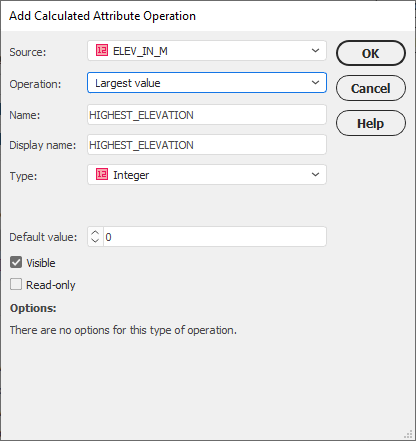
To add a Calculated Attribute, click the Add Operation button. The Add Attribute Operation dialogue box allows you to choose a source and new operation with associated options. Choose an Operation based on availability set by the attribute data type. Provide a Name, result type and provide settings for associated options.
Inclusion
There are two options to apply attribute operations to grouped components. Choose Apply to every grouped component option to apply all. Alternatively, choose Only apply to grouped components that satisfy to enable the expression builder to enter an expression that will only apply the attribute operations to values of the object where the expression condition is met. All other values that aren't satisfied will be cleared. For example, the expression "Continent = Africa" would only apply the operations to attributes of the object that has the attribute "Continent" and value of "Africa". All attributes for this art object will maintain its attributes.
Results
When all the options have been set click OK to join the points on the specified layer. A MAP Area or Line layer will be generated, depending on the specified output layer type, which will be placed in the same MAP View as the Input Point layer which has been joined.
Comments
0 comments
Please sign in to leave a comment.