Requirements
MAPublisher supports geospatial PDF documents generated from MAPublisher and Geographic Imager. It also supports third-party georeferenced PDF documents (e.g. from ArcGIS and TerraGo).
Using Geospatial PDF Import
Geospatial PDF Import is an easy way to import a geospatial PDF into Adobe Illustrator using MAPublisher. Its purpose is to import map data and organize information into MAP Layers in a MAP View. Begin to import a geospatial PDF from the File > Open menu. Browse for a geospatial PDF document and click Open. The Select PDF Import Method dialog box will open.
Select PDF Import Method
The Select PDF Import Method contains two options for import: Simple and Advanced.
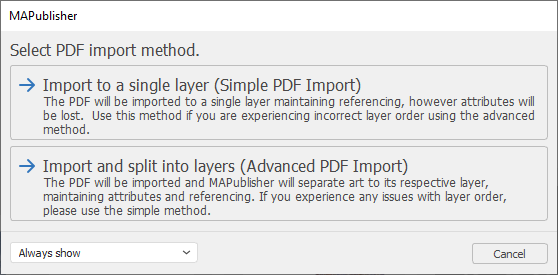
The Advanced PDF Import method is used to separate art to its respective layer. This method maintains attributes and referencing. It will open the Layer Assignment dialog box so that layers in the PDF can be assigned a MAPublisher feature type and a MAP View. In most cases, it is recommended to use Advanced PDF Import.
The Simple PDF Import method should be used in any layer order issues are caused by Multiple Data Import. This method will import features to a single MAP View and Adobe Illustrator layer. This method maintains referencing, however, all attribute information will be lost.
Layer Assignment
When Advanced PDF Import is used, it will open the Layer Assignment dialog box. It is used to assign the data structure found in a geospatial PDF to the appropriate Feature Type and a MAP View. It contains three columns: Layer, Feature Type, and MAP View. In the Feature Type column, the <Auto-detect> option automatically chooses the appropriate feature type (Area, Point, Line, Image, Text, or Legend) to assign each layer. Alternatively, click a Feature Type cell to assign a layer to the appropriate feature type (or to None for no feature type). Layers can be assigned to the Layers MAP View or to a Non-MAP Layer. Click OK to accept the layer assignments.
To assign the default layer assignments, click the Use Default button. Any changes made to the Feature Type and MAP View will not be used—it will use <Auto-detect> and the default MAP View.
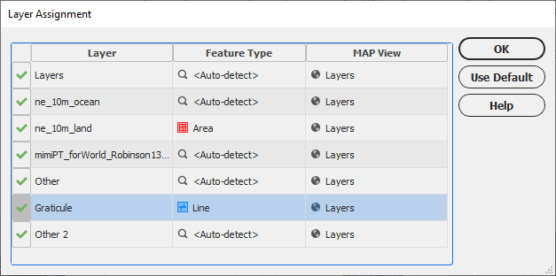
During import, MAPublisher is unable to assign layers to a MAP View when a geospatial PDF does not have any layer structure.
Notes about Geospatial PDF Import
Adobe Illustrator does not import layers set to invisible in a PDF document. This situation may happen if layers in MAPublisher are set to invisible and then exported to PDF. To prevent this from happening, ensure that all layers are made visible before export to PDF.
In certain cases, point objects may be imported as areas. Depending on how the authoring program created the PDF will determine how MAPublisher imports point objects. A possible workaround to this is to recreate point objects or create centroids using the existing areas in MAPublisher. Alternatively, try a different authoring program to export to PDF.
In certain cases, text objects are imported but every word is broken into independent characters. Resolving this issue is dependent on how the authoring program creates the PDF.
There are several TerraGo PDF export settings to be aware of. The Layer Menus export option provides a way to organize a layer listing in a PDF document but has no effect on layer structure. MAPublisher does not use this option during import. Also, the initial visibility for all layers you wish to import must be set to visible. MAPublisher is unable to import layers set to invisible by the TerraGo PDF exporter.
Comments
0 comments
Please sign in to leave a comment.